12 Freighter Travel Myths, Debunked (2026)
By Steve Joury / Novembre 4, 2026
Twelve common freighter travel myths checked against 2026 facts: cost, rules, piracy, cabins, internet, shore leave and carbon.
Read More
Last updated: 4 November 2026
The Strait of Malacca is the 900 km sea lane between Malaysia and Sumatra that carries more ships, and more seaborne oil, than any other chokepoint on Earth. More than 102,500 vessels passed through it in 2025. If you sail on a freighter between Europe and East Asia, you will almost certainly use it.
The strait runs north-west to south-east between the Malay Peninsula and the Indonesian island of Sumatra. At its northern end it opens into the Andaman Sea and the Indian Ocean. At its southern end it joins the Singapore Strait and the South China Sea.
It is the shortest sea route between the Indian Ocean and the Pacific. The alternatives, the Sunda and Lombok straits through Indonesia, add days to a voyage. That is why the strait matters to everyone from oil traders to freighter passengers.
The northern part is wide. The southern part is not. In the Singapore Strait, the Phillips Channel narrows to about 2.7 km. Depths in shallower parts are only around 25–27 metres. The largest crude carriers, with drafts over 20 metres, have little water to spare.
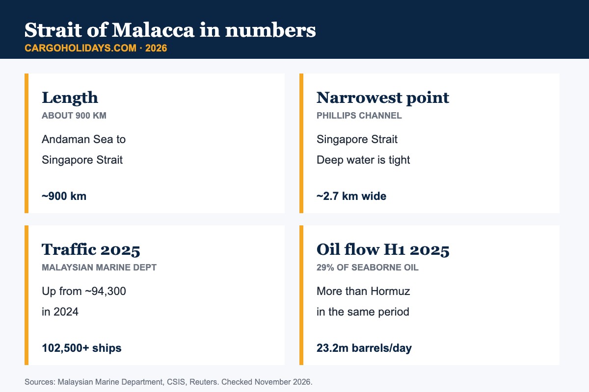
Malaysia’s Marine Department counted more than 102,500 transits in 2025. That is roughly one ship every five minutes, day and night. Traffic has risen steadily for years.
In the first half of 2025, about 23.2 million barrels of oil a day moved through the strait. That was 29% of all seaborne oil, and more than the Strait of Hormuz carried in the same period. Analysts estimate around three-quarters of China’s seaborne crude imports pass this way.
| Measure | Figure | Source |
|---|---|---|
| Lunghezza | About 900 km (550 miles) | Reuters |
| Narrowest width | About 2.7 km (Phillips Channel) | Reuters |
| Ships in 2025 | 102,500+ | Malaysian Marine Department |
| Ships in 2024 | About 94,300 | Malaysian Marine Department |
| Share of world maritime trade | About 22% | CSIS |
| Oil flow, H1 2025 | 23.2m barrels/day (29% of seaborne oil) | Reuters / Vortexa |
Two of the world’s biggest container ports sit on the strait. Most freighters call at one or both.
| Porto | 2025 containers | Note |
|---|---|---|
| Singapore | 44.66 million TEU (record) | 3.22 billion GT of arrivals; 56.77m tonnes of bunkers sold |
| Port Klang (Malaysia) | 15.14 million TEU (record) | Up 3.4% on 2024; among the world’s top 10 |
Singapore is also the world’s largest bunkering port. Many ships stop only to refuel, so the anchorages off the island are always crowded.
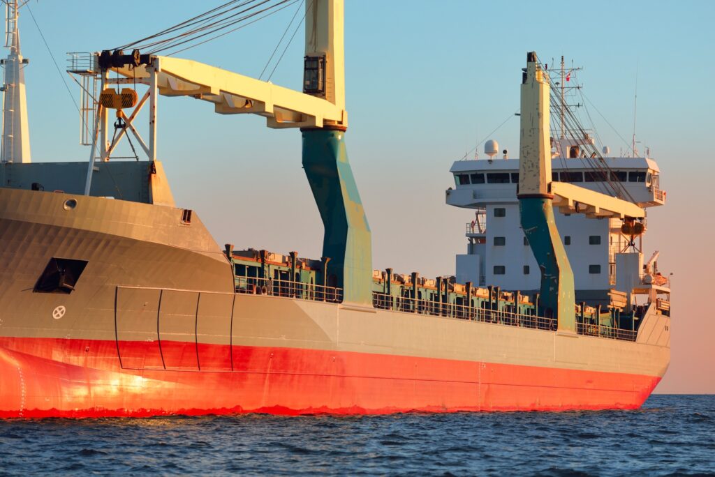
With this much traffic, ships cannot sail where they like. An IMO-adopted traffic separation scheme runs through the Straits of Malacca and Singapore. Eastbound and westbound ships keep to separate lanes, like a dual carriageway at sea.
Ships also report to shore stations in Malaysia, Singapore and Indonesia under a mandatory reporting system known as STRAITREP. Deep-draught vessels must keep a minimum under-keel clearance. From a freighter bridge, you will hear constant VHF traffic as ships report their positions.
The Straits of Malacca and Singapore had a bad 2025. ReCAAP ISC recorded 108 incidents there, the highest total since 2007. Most were petty thefts from ships underway at night, usually without injury to crew.
2026 looks very different so far. From January to September, ReCAAP logged 23 incidents in the straits, down from 97 in the same period of 2025. Across Asia, incidents fell 58%. Increased patrols and arrests are credited for the drop.
For passengers, the practical effect is small. Crews lock doors, rig lights and post extra watches at night. You may be asked to stay inside after dark in some stretches. See our guide to cargo ship piracy for more.
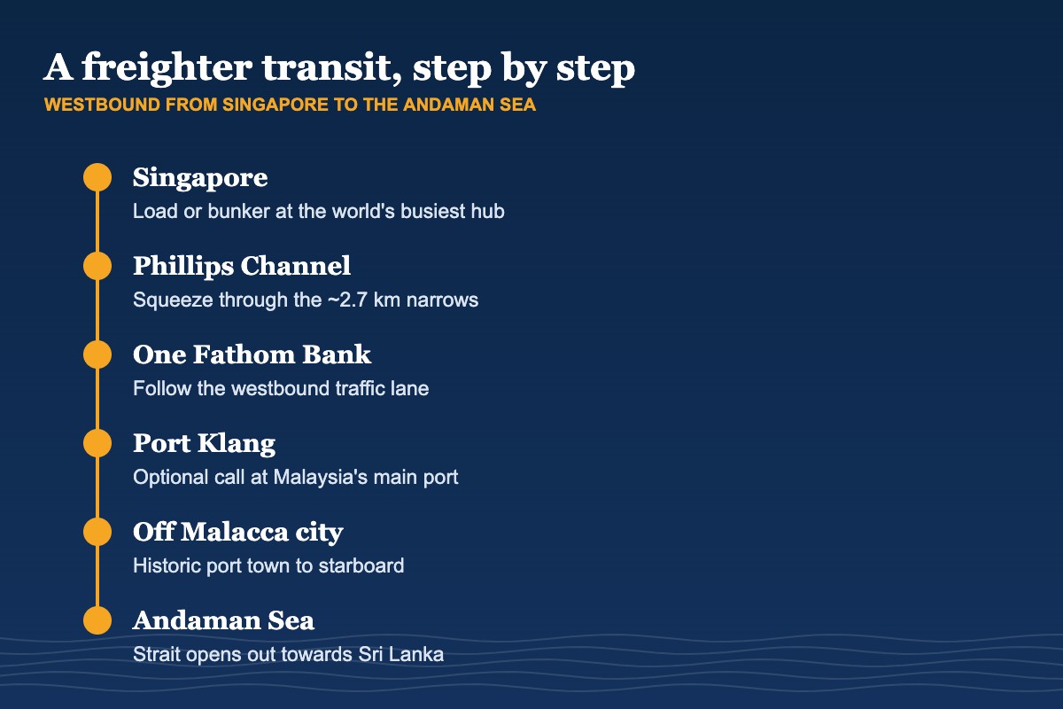
Almost every Europe–Asia container loop sails this way. A typical westbound rotation runs from China or Korea to Singapore, then up the strait to Sri Lanka, through the Suez Canal and on to the Mediterranean or North Europe. Eastbound ships do the reverse.
Some loops call at Port Klang as well as Singapore. Others skip one or the other. Itineraries change often, so check the latest rotation when you book. Our nave da carico diretta a Singapore e cargo ship to China guides cover the main options.
A full transit of the strait takes roughly a day and a half at normal service speed, depending on traffic and port calls. Expect to see ships on every horizon.
For centuries people have proposed cutting a canal across Thailand’s narrow Kra Isthmus to bypass the strait. No canal has ever been built.
Thailand’s current plan is a “Land Bridge” instead. It would link new deep-sea ports at Ranong on the Andaman coast and Chumphon on the Gulf of Thailand, about 90 km apart, by rail and road. The estimated cost is around 1 trillion baht (about US$30 billion). In mid-2026 the project was still under review, with a new environmental assessment ordered and investors cautious. Shipping lines would have to unload and reload cargo, which is why many analysts doubt it will draw traffic away from the strait.
The historic port of Melaka (Malacca) sits on the Malaysian shore, around two hours’ drive south of Kuala Lumpur. Portuguese, Dutch and British powers all held it. Its old centre is a UNESCO World Heritage Site, shared with George Town in Penang.
Container ships do not call at Malacca city. If you leave a freighter at Port Klang or Singapore, it makes an easy side trip by road.
| Chokepoint | Narrowest navigable width | Main role |
|---|---|---|
| Strait of Malacca | About 2.7 km (Phillips Channel) | Indian Ocean–Pacific; largest oil flow in H1 2025 |
| Strait of Hormuz | Two 3 km lanes | Gulf oil and gas exports |
| Strait of Gibraltar | About 14 km | Atlantic–Mediterranean; Suez traffic |
Read more in our Strait of Gibraltar shipping guide. The best weather for a transit is usually during the inter-monsoon months, though the strait is sheltered and sailable all year.
About 900 km (550 miles), from the Andaman Sea in the north-west to the Singapore Strait in the south-east.
The narrowest point is the Phillips Channel in the Singapore Strait, about 2.7 km (1.7 miles) wide.
More than 102,500 ships transited in 2025, according to Malaysia’s Marine Department, up from about 94,300 in 2024.
About 23.2 million barrels a day in the first half of 2025, or 29% of all seaborne oil flows.
ReCAAP recorded 108 incidents in the Straits of Malacca and Singapore in 2025, a 19-year high, mostly petty theft. From January to September 2026 incidents fell to 23.
Yes. Most Europe–Asia container services with passenger cabins pass through it, usually calling at Singapore and sometimes Port Klang.
Tell us your dates and ports. We will check current Europe–Asia rotations with passenger cabins.
Richiedi un preventivo per il viaggio →Sources: Reuters (April 2026), Malaysian Marine Department, CSIS, Vortexa, ReCAAP ISC Annual Report 2025 and January–September 2026 data, Maritime and Port Authority of Singapore, Port Klang Authority / Malay Mail, Reuters on Thailand’s Land Bridge (June 2026). Checked November 2026.