12 Freighter Travel Myths, Debunked (2026)
By Steve Joury / Novembre 4, 2026
Twelve common freighter travel myths checked against 2026 facts: cost, rules, piracy, cabins, internet, shore leave and carbon.
Read More
Last updated: 4 November 2026
English Channel shipping is among the densest in the world, with roughly 400–500 commercial ships passing through the Dover Strait every day. At its narrowest the strait is only about 33 km (20.6 miles) wide, between South Foreland and Cap Gris-Nez. Through that gap run the main sea route between the Atlantic and northern Europe’s biggest ports, plus one of the busiest ferry crossings anywhere.
The Channel is the only direct sea link between the Atlantic and the North Sea. Ships heading to Rotterdam, Antwerp-Bruges, Hamburg, Bremerhaven, Felixstowe and London Gateway all funnel through it. The alternative — round the north of Scotland — adds days.
On top of this east–west flow sits heavy north–south traffic. Ferries link Dover with Calais and Dunkirk all day and night. Fishing boats, yachts and survey vessels add to the mix. The result is a crossroads at sea.
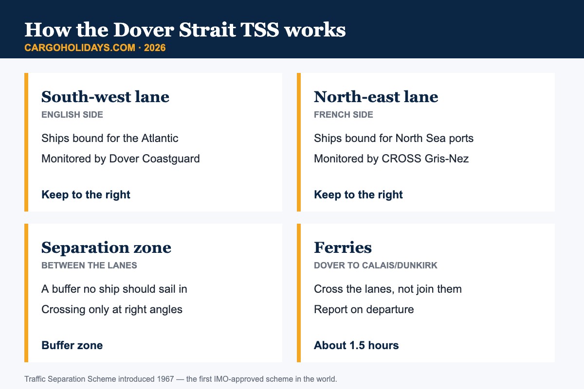
Before the 1960s, ships picked their own route through the strait, and collisions were common. In 1967 a Traffic Separation Scheme was introduced. It was the first scheme approved by the International Maritime Organization (IMO). It became compulsory when the 1972 Collision Regulations (Rule 10) came into force in 1977.
The scheme works like a dual carriageway. South-west-bound ships use the lane nearer England. North-east-bound ships use the lane nearer France. A separation zone keeps the two apart. Vessels that must cross the lanes, such as ferries, do so as close to a right angle as possible.
| Fatto | Dettagli |
|---|---|
| Narrowest width | About 33 km (20.6 miles), South Foreland to Cap Gris-Nez |
| Depth | Roughly 35–55 m (120–180 ft) |
| Commercial ships per day | About 400 (estimates up to 500+) |
| TSS introduced | 1967 — first IMO-approved scheme |
| CNIS established | 1972 |
| Mandatory reporting | CALDOVREP, ships of 300 GT and over |
The Channel Navigation Information Service (CNIS) was set up in 1972. It gives round-the-clock radar and AIS surveillance of the strait. The UK side is run from HM Coastguard at Dover. The French side is run by CROSS Gris-Nez on the cliffs near Cap Gris-Nez.
Under the CALDOVREP reporting system, ships of 300 gross tonnage and over report in. Those entering from the south-west call Dover Coastguard. Those entering from the north-east call Gris-Nez. Both centres broadcast traffic and safety information, and can identify ships that break the rules — for example, a vessel sailing the wrong way down a lane.

Dover–Calais is the main short-sea ferry route across the strait. In 2026 three operators sail it: DFDS, P&O Ferries and Irish Ferries. Crossings take about 1 hour 30 minutes. Combined, the operators offer roughly 24–31 sailings a day, depending on season and schedule. DFDS also runs Dover–Dunkirk.
Every one of those sailings must cut across both lanes of through traffic. That is why ferry bridge teams and CNIS stay in constant contact.
| Operator | Percorso | Typical crossing |
|---|---|---|
| DFDS | Dover–Calais, Dover–Dunkirk | ~1 h 30 min (Calais) |
| P&O Ferries | Dover–Calais | ~1 h 30 min |
| Irish Ferries | Dover–Calais | ~1 h 30 min |
Timetables and prices change often. Check the operator before you travel; figures here are indicative.
If you book a cargo-ship voyage between northern Europe and almost anywhere south or west, you will pass through the Channel. Asia–Europe container loops heading to Rotterdam, Antwerp or Hamburg run up the Channel. So do Mediterranean, West African and transatlantic services. Ro-ro and car-carrier routes serving Southampton and Zeebrugge sail here too.
For passengers, the passage is a highlight. You see the white cliffs of Dover on one side and the French coast on the other, with ships ahead and behind in a steady line.
The lanes are safe today, but the Channel’s history shows why they exist.
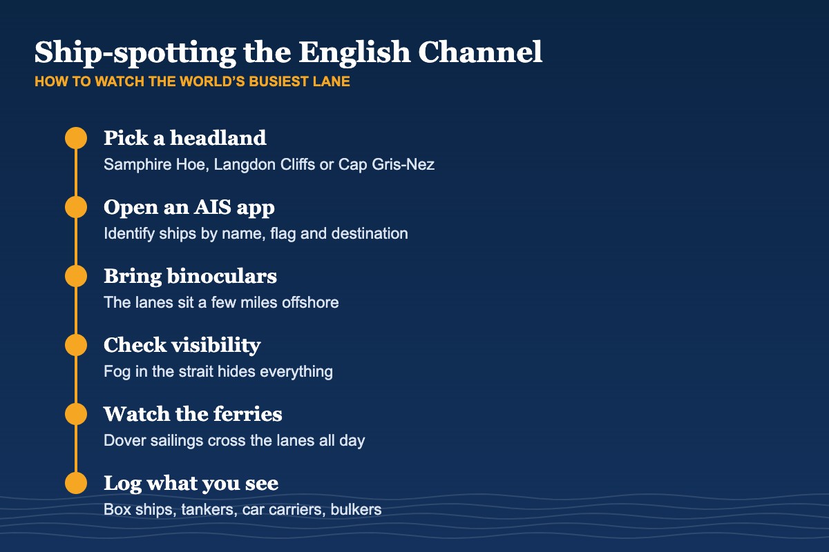
You don’t need to be at sea to see the traffic. On the English side, Samphire Hoe and Langdon Cliffs (White Cliffs of Dover) give wide views of the lanes and the port. Dover’s seafront and harbour walls are good for ferries. In France, Cap Gris-Nez and Cap Blanc-Nez look straight over the strait, and on a clear day you can see England.
An AIS tracking app turns a distant hull into a named ship with a flag and destination.
| Season | Conditions | Spotting tip |
|---|---|---|
| Spring | Clearer air, fewer storms | Good visibility to France |
| Summer | Busiest ferries, calmer seas | Go early or late for light |
| Autumn | Gales and swell begin | Dramatic seas, check forecasts |
| Winter | Fog and storms more likely | Fewer crowds; disruptions possible |
About 400 commercial ships a day transit the Dover Strait. Wider estimates including ferries and other traffic run to 500 or more.
In 1967. It was the first traffic separation scheme approved by the IMO, and became compulsory in 1977 under the 1972 Collision Regulations.
The Channel Navigation Information Service (CNIS), run jointly by HM Coastguard at Dover and France’s CROSS Gris-Nez.
DFDS, P&O Ferries and Irish Ferries. Crossings take about 1 hour 30 minutes.
The car carrier sank after colliding with the container ship Kariba off Dunkirk on 14 December 2002, with nearly 2,900 cars aboard. No one died.
Samphire Hoe and Langdon Cliffs near Dover, or Cap Gris-Nez and Cap Blanc-Nez in France.
Many freighter voyages from northern Europe pass through the Dover Strait. Tell us where you’d like to go and we’ll look for a cabin.
Richiedi un preventivo per il viaggio →Sources: Marine Insight (Strait of Dover); GOV.UK / MCA (CNIS, MGN 364); IMO ships’ routeing history; Wikipedia and Cedre (Tricolor); Direct Ferries (Dover–Calais operators). Checked November 2026.